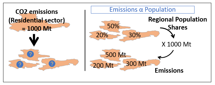
Figure 1 – Spatial disaggregation of CO2 emissions from the residential sector. These emissions are distributed proportional to population numbers. Please note that the values here are strictly exemplary.
LOCALISED aims to provide climate action plans at a community-relevant, local administration decision scale for all the EU27 countries. As a result, a major part of the work carried out within the project involves spatial disaggregation of country-level decarbonisation trajectories to a regional level.
In a nutshell, spatial disaggregation methods aid in increasing the spatial resolution of the data. These methods employ proxy data, available at a fine resolution, to distribute the data available at a coarser resolution. A simple example of this process is shown in Figure 1. Here, the emissions from the residential sector are spatially disaggregated based on population numbers.

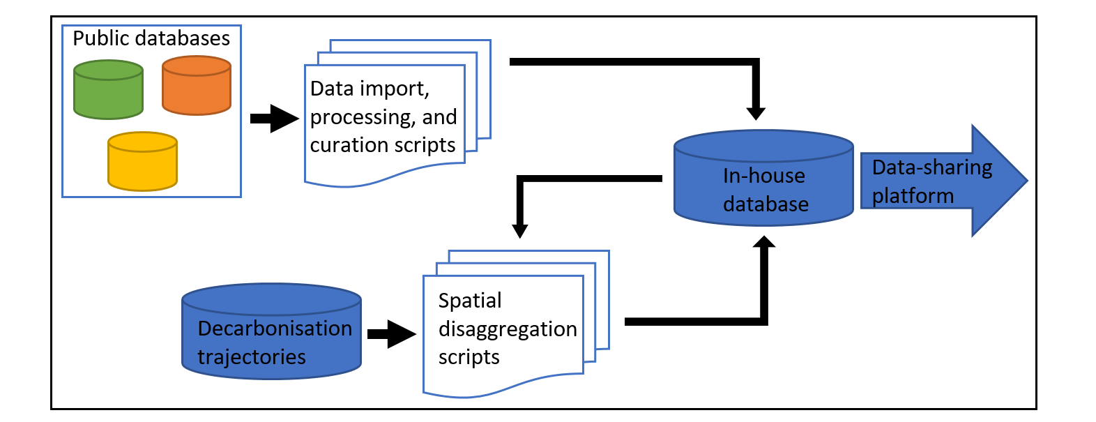
Figure 2 – Workflow involved in the disaggregation of decarbonisation trajectories and provision of all the data collected in the process through the LOCALISED data-sharing platform.
The decarbonisation trajectories [1] involve several attributes on various themes such as sectoral emissions, electricity and heat generation, sectoral electricity and heat demand, etc. The spatial disaggregation of the plethora of attributes requires collection of spatially highly resolved data on various themes such as demography, local climate conditions, infrastructure status, road and rail networks, landscape features, etc. Moreover, this data is required for all the EU27 countries.
A one-stop, open-source database that provides data at a fine spatial resolution of NUTS3 [2] or finer Local Administrative Unit (LAU) [3] resolution for all the EU27 countries is required to spatially disaggregate the decarbonisation trajectories.
Due to lack of such a database, we are building our own. To that end, we collect, process, and curate data from different public databases at NUTS3, and where possible, LAU spatial level. We plan to make this database openly accessible via our data-sharing platform. What’s more, the spatially disaggregated decarbonization trajectories will also be published via this platform. Figure 2 shows the entire workflow leading up to the data-sharing platform.
We believe that the data-sharing platform will be indispensable to energy system modelers, researchers focusing on mitigation and adaptation measures at a regional scale and local administrations, across the EU.
A pilot version of the LOCALISED data-sharing platform is planned to be released to the public in July 2023. An update regarding the access and usage of the platform will follow soon.
References:
[2] NUTS – GISCO – Eurostat (2021). NUTS – GISCO – Eurostat, 2021 [Dataset]. https://ec.europa.eu/eurostat/web/gisco/geodata/reference-data/administra-tive-units-statistical-units/nuts (accessed Nov. 23, 2022).
[3] GISCO – Eurostat, “LAU – GISCO – Eurostat,” 2020. https://ec.europa.eu/eurostat/web/gisco/geodata/reference-data/administrative-units-statistical-units/lau (accessed Nov. 23, 2022).

Recent Comments